Back Nedersakse Afrikaans Niedersachsen ALS ኒደርዛክስን Amharic Baixa Saxonia AN Niðerseaxland ANG سكسونيا السفلى Arabic نيديرزاكسين ARZ Baxa Saxonia AST Niedersachsen suyu Aymara Aşağı Saksoniya Azerbaijani
Lower Saxony
| |
|---|---|
 | |
| Coordinates: 52°45′22″N 9°23′35″E / 52.75611°N 9.39306°E | |
| Country | Germany |
| Capital | Hanover |
| Government | |
| • Body | Landtag of Lower Saxony |
| • Minister-President | Stephan Weil (SPD) |
| • Governing parties | SPD / Greens |
| • Bundesrat votes | 6 (of 69) |
| • Bundestag seats | 73 (of 736) |
| Area | |
| • Total | 47,614.07 km2 (18,383.90 sq mi) |
| Population (2021-12-31)[1] | |
| • Total | 8,003,421 |
| • Density | 170/km2 (440/sq mi) |
| GDP | |
| • Total | €339.414 billion (2022) |
| • Per capita | €41,826 (2022) |
| Time zone | UTC+1 (CET) |
| • Summer (DST) | UTC+2 (CEST) |
| ISO 3166 code | DE-NI |
| NUTS Region | DE9 |
| HDI (2019) | 0.935[3] very high · 11th of 16 |
| Website | www |

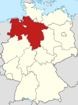
Lower Saxony[a] is a German state (Land) in northwestern Germany. It is the second-largest state by land area, with 47,614 km2 (18,384 sq mi), and fourth-largest in population (8 million in 2021) among the 16 Länder federated as the Federal Republic of Germany. In rural areas, Northern Low Saxon and Saterland Frisian are still spoken, albeit in declining numbers.
Lower Saxony borders on (from north and clockwise) the North Sea, the states of Schleswig-Holstein, Hamburg, Mecklenburg-Vorpommern, Brandenburg, Saxony-Anhalt, Thuringia, Hesse and North Rhine-Westphalia, and the Netherlands. Furthermore, the state of Bremen forms two enclaves within Lower Saxony, one being the city of Bremen, the other its seaport, Bremerhaven (which is a semi-enclave, as it has a coastline). Lower Saxony thus borders more neighbours than any other single Bundesland. The state's largest cities are the state capital Hanover, Braunschweig (Brunswick), Oldenburg, Osnabrück, Wolfsburg, Göttingen, Salzgitter, Hildesheim, mainly situated in its central and southern parts, except Oldenburg and Lüneburg.
Lower Saxony is the only Bundesland that encompasses both maritime and mountainous areas. The northwestern area of the state, on the coast of the North Sea, is called East Frisia and the seven East Frisian Islands offshore are popular with tourists. In the extreme west of Lower Saxony is the Emsland, an economically emerging but rather sparsely populated area, once dominated by inaccessible swamps. The northern half of Lower Saxony, also known as the North German Plain, is almost invariably flat except for the gentle hills around the Bremen geestland. Towards the south and southwest lie the northern parts of the Central Uplands: the Weser Uplands and the Harz Mountains. Between these two lie the Lower Saxon Hills, a range of low ridges.
The region in the northeast, the Lüneburg Heath (Lüneburger Heide), is the largest heathland area of Germany. In the Middle Ages, the town of Lüneburg was wealthy due to salt-mining and the salt trade. To the north the Elbe valley separates Lower Saxony from Hamburg, Schleswig-Holstein, Mecklenburg-Vorpommern, and Brandenburg. The left banks of the Elbe downstream Hamburg are known as the Altes Land (Old Country). Due to its gentle local climate and fertile soil, it is the state's largest area of fruit farming, its chief produce being apples.
Most of the state's territory was part of the historic Kingdom of Hanover, and the state of Lower Saxony has adopted the coat of arms and other symbols of the former kingdom. It was created by the merger of the State of Hanover with three smaller states on 1 November 1946.
- ^ "Landesamt für Statistik Niedersachsen".
- ^ "Bruttoinlandsprodukt, Bruttowertschöpfung | Statistikportal.de". Statistische Ämter des Bundes und der Länder | Gemeinsames Statistikportal (in German). Retrieved 31 July 2023.
- ^ "Sub-national HDI – Area Database – Global Data Lab". hdi.globaldatalab.org. Retrieved 6 May 2022.
Cite error: There are <ref group=lower-alpha> tags or {{efn}} templates on this page, but the references will not show without a {{reflist|group=lower-alpha}} template or {{notelist}} template (see the help page).
© MMXXIII Rich X Search. We shall prevail. All rights reserved. Rich X Search

